Tigh
Na Locha
Self Catering
Semi-Detached Accommodation in Morar
near
Mallaig, in the West Highlands of Scotland
Home Inside Outside Local Area Things to Do Booking & Contact Location & Directions
Location Maps and Directions
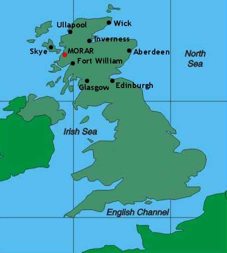
Overlooking Loch Morar, Tigh na Locha is in the village of
Morar in the West Highlands of Scotland, located 3 miles
(5 kilometers) south of Mallaig and 40 miles (56 kilometers)
north west of Fort William.
Trains
Scotrail operate a
regular rail service from Fort William stopping at Morar which takes
around 1 hour 15 minutes. For details, check their website:
• ScotRail
Airports
The following airports
all offer internal and international flights and you can check
their websites for details:
• Glasgow
Airport
• Inverness
Airport
• Edinburgh
Airport
Coaches
Citylink run services
to Morar from Fort William, but do check times and availability
(especially at weekends) from their website:
• Citylink
Taxis
Both the following
taxi operators are based in Fort William and offer tours as well
as services to and from the airports:
• Al's
Taxis
• Robertson's
Taxis
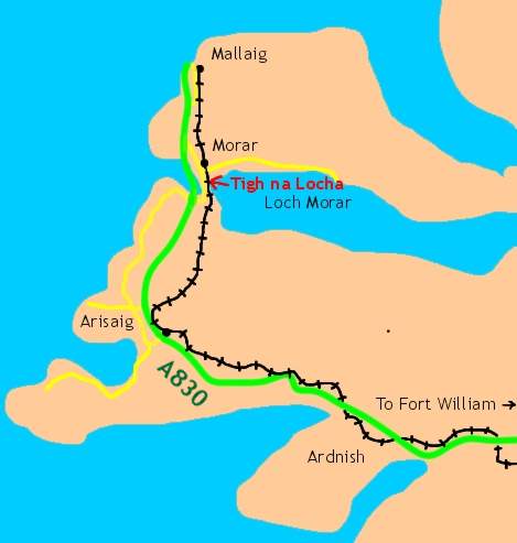
(scale:
width of map about 14 miles, 20 kilometers)
for greater detail of this area, click StreetMap
Car
Morar is easily reached
taking the A830 from Fort Willaim signposted to Mallaig and the
'Road to the Isles'.
To get comprehensive directions, use this link to the AA Route Planner and enter 'Morar' as your destination
Roughly 38 miles from Fort William, and 3 miles after passing signs to Arisaig on your left you will see signs to the Silver Sands also on the left. Very shortly after this turn right signposted Loch Morar and Bracara.
Follow the road over the single-track short bridge over the River Morar and under the railway bridge (watch out for traffic coming from the blind curve from the left).
After the railway bridge, turn right and follow the road with water to your right (this is River Morar exiting Loch Morar through the small hydro-electric dam).
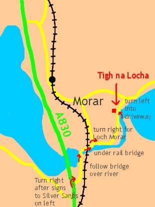
(scale:
width of map just over 1 mile, 1.7 kilometers)
for greater detail of this area, click StreetMap
(note: the Ordnance
Survey map used by StreetMap
at this scale does not show
the A830,
but don't worry - it's still there !)
After the river and a bend to the left, follow the nearly straight road passing some houses on your left. Just as some boats come into sight moored near the slipway to your right, keep an eye out for a gravel driveway on your left marked "Tigh na Locha" .
Turn left into the driveway and park in the area in front of the garden (if you get to a junction on the left and church in front of you, you've gone a little too far: just turnaround and it's a few yards on the right). Tigh na Locha is the semi-detached house in front of you, entrance from the porch on the left.
Now relax - your perfect holiday has just begun !
Home Inside Outside Local Area Things to Do Booking & Contact Location & Directions
Website designed and maintained by Chris
Wallace Last updated: 14th November 2005
Design
and text copyright: Anne Skea Photographs copyright: Chris Wallace